 GeoData.NZ
Toitū Te Whenua (LINZ)
Type of resources
Topics
Keywords
Contact for the resource
Provided by
Years
Update frequencies
status
-

A tide gauge was installed in November 1990 and has been in near continuous operation since. A 10 minute average of water depth was recorded each hour with hourly averages of wind speed and direction, air temperature and solar radiation. From 2000 the recording frequency was increased from every hour to every 10 minutes. From 2003 data is read every 10 seconds and an average value (from 60 readings) is calculated every 5 minutes and recorded. Barometric pressure was measured as well, starting in 2003, with six barometric pressure readings made between 2 and 3 minutes in the 5-minute interval and averaged and recorded with the tide value. Each year the rise and fall of the sea ice is observed over a 2 - 3 day period during a spring tide using GPS. These measurements are related to a tide gauge bench mark and the sea surface to enable the reliability of the tide gauge to be checked. The tide gauge data is archived by Land Information New Zealand. GET DATA: https://sealevel-data.linz.govt.nz/index.html?tidegauge=ROBT
-

A sea level recorder and barometer was installed at Scott Base in January 2001 initially to support oceanographic and hazards research (including tsunami) and to support hydrographic surveying. The sea-level recorder is a nitrogen bubbler system with a paroscientific pressure transducer located on a bottom-mounted spigot of the osmosis boom (to enable lifting for maintenance), that ensures the orifice always returns to the same point. Sea level and atmospheric pressure and temperature are recorded at 5 minute intervals and stored every 24 hours. Each year the rise and fall of the sea ice is observed over a 2-3 day period during a spring tide using GPS. These measurements are related to a tide gauge benchmark and the sea surface to enable the reliability of the tide gauge to be checked. GET DATA: https://sealevel-data.linz.govt.nz/index.html?tidegauge=SCOT
-
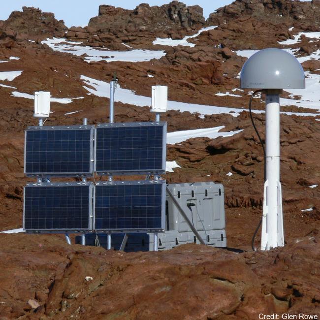
The network collects Global Navigation Satellite System (GNSS) data for the purposes of monitoring the New Zealand Geodetic Datum 2000 (NZGD2000), updating the national deformation model, and maintaining New Zealand’s relationship to the International Terrestrial Reference Frame (ITRF). Antarctic GNSS data form part of the New Zealand campaign GNSS (Global Navigation Satellite System) surveys. Data have been collected by periodic campaign style GNSS surveys. High accuracy continuous Global Positioning System tracking stations in Antarctica: - Scott Base (SCTB - LINZ Geodetic Code) and was operational as of 29 October 2004. - Butcher Ridge (BURI- LINZ Geodetic Code) on 7 December 2007. - Minna Bluff (MIN0- LINZ Geodetic Code) on 31 January 2007. - Cape Roberts (ROB4- LINZ Geodetic Code) on 29 November 2005. Data are available in Receiver Independent Exchange Format (RINEX) files at 30 or 15 seconds sampling rate. GET DATA: https://www.geodesy.linz.govt.nz/positionz/?page=text GET DATA: https://www.linz.govt.nz/products-services/geodetic/positionz/positionz-real-time-service